

IT’S A REVOLUTION. IN ONE STATION
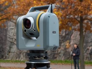
The Trimble® SX10 scanning total station redefines the capabilities of everyday survey equipment by providing the world’s most innovative solution for surveying, engineering, and scanning professionals. The Trimble SX10 will change the way you work. This new, versatile solution is capable of collecting any combination of high-density 3D scan data, enhanced Trimble VISION™ imaging, and high‑accuracy total station data, allowing you to capture exactly what you need, saving you time and money on every job.
Trimble’s new Lightning 3DM enables the SX10 to capture both high-accuracy total station measurements and true high-speed 3D scans together in a single instrument providing a higher level of measurement performance than ever before. The system has been designed from the ground up leveraging trusted technologies like MagDrive™ and SurePoint™. Combining these with new technologies like advanced Autolock® allow the SX10 to deliver maximum accuracy, efficiency and detail. The complete integration of the SX10 with Trimble Access™ and Trimble Business Center software enable familiar and efficient survey workflows to get your crews up and running fast
sx10
۳D Scanning That’s Superior in Every Way
The Trimble SX10 measures dense 3D scan data at up to 26,600 Hz with high precision over the full measurement range of up to 600 m. With the Trimble SX10, point cloud data is captured and then automatically
registered with your survey workflow. Whether you’re capturing full dome scans from your station setup or simply augmenting your survey data with scans of specific areas of interest, be confident that all of the information you gather will drop right into your survey coordinate system.
VISION That’s Even Better Than Ever
The unique implementation of Trimble VISION technology onboard the Trimble SX10 gives you more power than ever to direct your survey with live video images on the controller as well as create a wide variety of deliverables from collected imagery. From the very beginning, you’ll find it gives users in any setting a new, higher level of performance, including the ability to capture full dome panoramas in as little as three minutes. And it offers varying levels of imaging capabilities and resolutions, whether you’re documenting your site, or capturing additional visual detail on your DR observations.
Get the Most Out of Your Field Data With TBC
Back in the office Trimble Business Center lets you fully integrate Trimble SX10 data into your projects using the familiar workflows of the market leading survey office software. Enhanced point cloud management, automated extraction and interoperability to leading CAD and GIS packages ensures that you can satisfy even your toughest client demands.
Unparalleled Precision. Unrivaled Performance.
The Trimble SX10 scanning total station sets a new standard for accuracy, capability and performance. Whether you’re performing a typical job or your most challenging survey projects, the SX10 gives you the confidence to do it all and do it well.
Key Features
Combines surveying, imaging and high speed 3D scanning in one revolutionary solution
Trimble’s Lightning 3DM enables both high-accuracy total station measurements and high-speed scanning capability
Scanning speeds of up to 26,600 Hz at ranges up to 600 m and the smallest spot size in the industry—a mere 14 mm at 100 m
Improved Trimble VISION technology allows for fast and easy capture of high resolution site imagery
Complete integration with familiar workflows of Trimble Access and Trimble Business Center Software
SURVEY PERFORMANCE
ANGLE MEASUREMENT
Sensor type Absolute encoder with diametrical reading
Angle measurement accuracy 1” (۰٫۳ mgon)
Angle display (least count) 0.1″ (0.01 mgon)
AUTOMATIC LEVEL COMPENSATOR
Type Centered dual-axis
Accuracy 0.5″ (0.15 mgon)
Range ±۵٫۴’ (±۱۰۰ mgon)
Electronic 2-axis level, with a resolution of 0.3” (۰٫۱ mgon)
Circular level in tribrach 8’/۲ mm
DISTANCE MEASUREMENT
Accuracy
Prism mode Standard2 1 mm + 1.5 ppm
Tracking2, 3 2 mm + 1.5 ppm
DR mode Standard2 2 mm + 1.5 ppm
Measuring time
Prism mode Standard 1.6 s
DR mode Standard 1.2 s
Range
Prism mode 1 prism 1 m – ۵,۵۰۰ m
DR mode Kodak White Card (Catalog number E1527795) 1 m – ۸۰۰ m
Kodak Grey Card (Catalog number E1527795) 1 m – ۴۵۰ m
Autolock and Robotic Range
Autolock range – traverse 50 mm5 1 m – ۸۰۰ m
Autolock range – 360 prism 1 m – ۳۰۰ m6
/ ۷۰۰ m5
Angle accuracy 1″
SCANNING PERFORMANCE
GENERAL SCANNING SPECIFICATIONS
Scanning principle Band scanning using rotating prism in telescope
Measurement rate 26.6 kHz
Point spacing 6.25 mm, 12.5 mm, 25 mm or 50 mm @ 50 m
Field-of-view 360° x 300°
Coarse scan;
full dome – 360° x 300° (horizontal angle x vertical angle)
Density: 1 mrad, 50 mm spacing @ 50 m
Scan time: 12 minutes
Standard scan;
area scan – 90° x 45° (horizontal angle x vertical angle)
Density: 0.5 mrad, 25 mm spacing @ 50 m
Scan time: 6 minutes
RANGE MEASUREMENT
Range principle Ultra-high speed time-of-flight powered by
Trimble Lightning technology
Range
Kodak White Card (Catalog number E1527795) 0.9 m – ۶۰۰ m
Kodak Gray Card (Catalog number E1527795) 0.9 m – ۳۵۰ m
Range noise
@ ۵۰ m on 18–۹۰% reflectivity 1.5 mm
@ ۱۲۰ m on 18–۹۰% reflectivity 1.5 mm
@ ۲۰۰m on 18-90% reflectivity 1.5mm
@ ۳۰۰m on 18-90% reflectivity 2.5mm
Scanning Accuracy
Scanning Angular Accuracy 5” (۱٫۵mgon)
۳D position Accuracy @ 100m8 2.5mm
EDM SPECIFICATIONS
Light source Pulsed laser 1550 nm; Laser class 1M
Beam divergence DR mode 0.2 mrad
Laser spot size at 100 m (FWHM) 14 mm
Atmospheric correction Available through field and office software
IMAGING PERFORMANCE
Imaging principle 3 calibrated cameras in telescope powered by
Trimble VISION technology
Cameras total field of view 360° x 300°
Live view frame rate (depending on connection) Up to 15 fps
File size of one total panorama with overview camera 15 MB – ۳۵ MB
Panorama measurement time/resolution
Overview panorama Full dome 360° x 300°
(Horizontal angle x vertical angle) with 10% overlap
۳ minutes, 40 images, 20 mm @ 50 m per pixel
Primary panorama Area capture 90° x 45°
(Horizontal angle x vertical angle) with 10 % overlap
۳ minutes, 48 images, 4.4 mm @ 50 m per pixel
CAMERAS SPECIFICATIONS
General Camera Specifications
Resolution of each camera chip 5 MP (2592 x 1944 pix)
File format of images .jpeg
Field of view max 57.5° (horizontal) x 43.0° (vertical)
Field of view min 0.65° (horizontal) x 0.5° (vertical)
Total zoom (no interpolation) 84 x
۳۵ mm equivalent focal length 36–۳۰۰۰ mm
Exposure modes Auto, spot exposure
Manual exposure brightness ±۵ steps
White balance modes Auto, daylight, incandescent, overcast
Temperature compensated optics Yes
Calibrated cameras Yes
Overview Camera
Position Parallel to measurement axis
One pixel corresponds to 20 mm @ 50 m
Primary Camera
Position Parallel to measurement axis
One pixel corresponds to 4.4 mm @ 50 m
Telescope Camera
Position Coaxial
Focusing Automatic, manual
Focusing distance 1.7 m to infinity
One pixel corresponds to 0.88 mm @ 50 m
Pointing precision (std dev 1 sigma) 1″ (HA: 1,5 cc, VA: 2,7 cc)
Plummet Camera
Usable range 1.0–۲٫۵ m
Resolution on ground – one pixel corresponds to 0.2 mm @ 1.55 m instrument height
Accuracy 0.5 mm @ 1.55 m instrument height
GENERAL SPECIFICATIONS
Communication WiFi, 2.4 Ghz Spread Spectrum, cabled (USB 2.0)
IP-rating IP55
Operating temperature range –۲۰ °C to 50 °C
Security Dual layer password protection
SYSTEM SPECIFICATIONS
SERVO SYSTEM
MagDrive servo technology Integrated servo/angle sensor electromagnetic
direct drive
Clamps and slow motions Servo-driven
CENTERING
Centering system Trimble 3-pin
Plummets Built-in video plummet
Split optics tribrach with optical plummet
POWER SUPPLY
Internal battery Rechargeable Li-Ion battery 11.1 V, 6.5 Ah
Operating time
One internal battery Approx. 2–۳ hours
Three internal batteries in multi-battery adapter Approx. 6–۹ hours
WEIGHT AND DIMENSIONS
Instrument 7.5 kg
Tribrach 0.7 kg
Internal battery 0.35 kg
Trunnion axis height 196 mm
Front lens aperature 56 mm